

Here we are providing notes for Mppsc mp gk. Physical division of Madhya Pradesh for MPPSC exam. the division of Madhya Pradesh according to geographical location and climate differences in different regions is different.
Madhya Pradesh is Divided into three geographic divisions
1. Central highlands
2. satpura maikal ranges
3. eastern plateau
2. satpura maikal ranges
3. eastern plateau
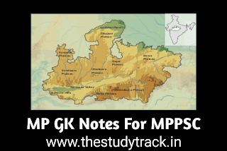
These are classified into different plateaus, valleys, and hilly regions
.webp "physical division of madhya pradesh")
Central Highlands
Classified into five sub-regions or Plateaus they are - central India Plateau, Bundelkhand, Rewa Panna Plateau, Malva Plateau, Narmada Son Valley,
Central india plateau
Comprises of the north-western part of Madhya Pradesh
Location between 24°00’ to 26°48’ north latitude and 74°50’ to 79°10’ eastern longitude.
Area 10.7 % of the total geographical area of MP extended to Bhind, Morena, Seopur, Gwalior Shivpuri, guna, and Mandsaur.
Formation from erosion and deposition of Vindhyan rock group.
Region drained by rivers Chambal, Sindh, Kalisindh, Parvati,kuari, seep,kuno, etc.
Forest thorny/dry forest, trees like khair(catechu), Babool, Palash, found here.
Soil - Alluvial and alluvium and this region is suitable for crops like wheat, barley, Jowar, and oilseed.
This region is known as 'mustard pot'(Sarso ki handi) due to the production of Mustard. This region suffered from gully erosion by the Chambal River. Formed chambal strike valley deposition of alluvial soil.
The highest peak of the the central India plateau is Tongra which is 430 meters located in Seopur district and the average height of this plateau is approximately 300m.
Bundelkhand plateau
Location Latitude- 24°6’ to 26°22’ north and Longitude - 77°51’to 80°20’ east
Area 7.7% of total area extended in Sagar, Damoh, Panna, Chatarpur, Tikamgarh, Niwari, Ashoknagar, Datia, and Shivpuri districts of MP. Surrounded by Panna series, bijawar series, Chanderi low plateau.
Formed from a volcanic eruption and Bundelkhand gneiss rock. That is why diamond and limestone are important minerals found.
Region drained by rivers like Sindh, Betwa Urmil,jamini, Ken Tons, and Dhasan.
Forest - vegetation Tendu, Mahua, khair, babool neem.
Soil mixed red-black, region suitable for wheat, jowar, sesame, Average rain 75 to 100 cm. This is most dry region of mp
The elevation is 150m to 450m and the highest peak of Bundelkhand plateau is Sidh Baba which is 1172m.
Peneplains are found between Jhansi and Sagar, and Tors (small hills) are found in these plains.
Malva Plateau
Located between Latitude - 20°10’-25°8’ North and Longitude- 74°20’- 79°20’East.
Area comprises 28 percent extended in districts Indore,Ujjain, dewas, ratlam, Sajapur, agar malva, Rajgarh, etc.
Formed from deccan trap volcanic eruption basalt rocks.
Black soil is found here suitable for crops like soybean,cotton, wheat, jowar,groundnut.gram,pulses,sugarcane.
Average elevation is 300 to 450m. Cigar is height peak of malva plateau located in indore district.
This region drained by rivers like chambal, kshipra,kalisindh,parvati,shivna,Mahi. Average rainfall is 75 to 125 cm.
Forest Vegetation dry forest consist scattered trees leke teak sal sagon and scrubs are also found here.
This region is known Basket of Wheat,
Rewa Panna plateau
Located between Latitude - 23°10’- 25°12 North latitude’ and Longitude - 78°4’- 82°18’ east longitude
Area comprises of 10.36 percent extended in districts Panna, Rewa, Satna, sidhi, Maihar, Mahuganj districts of mp
Soil Mixed soil found suitable crops are wheat and paddy (rice)
Formed from Vindhyan rocks erosion and minerals like limestone, geru dolomite gypsum,quarzite and diamond found.
Drained by rivers like tons, Bihad, Ken and average rain is 125 cm.
Vindhyan scatplands are found here
Average elevation is 300 to 400m Sadbhavna shikhar i.e. Goodwill peak is highest peak of rewa panna plateau which is 752m located in Damoh.
Narmada Son valley
Location between Latitude - 23°30’ - 23°45’ North and Longitude- 74°30’ - 81°30’ East
Consist of 26 percent of total area extended in districts Mandala, Jabalpur, Hoshangabad, Khandwa, Khargon, Badwani, Harda, Dhar, Dewas.
Formed from deccan trap and dharwad and vindhyan rock. Minerals like limestone, Marble,china clay.
Forest vegetation Sagon, sal, bamboo,
Soil is dark black soil in the west and red soil in the eastern part crops like groundnut, wheat, sugarcane, and pulses are grown
This region is drained by rivers like Narmada, Son, johila, Dudhi, Hiran, Sher, Barna, Shakkar,Kolar
The average elevation is the lowest and this is the lowest topography of mp State.
This region is known as the back backbone of the agriculture economy highest production of wheat sugarcane and other crops.
Satpura Maikal ranges
Located between 21°30’ - 23°30’ North Latitude 74°30’- 81°30’ East longitude
Divided into three regions western(Rajpipla) central (Mahadev) and eastern ranges(Maikal hills).
Comprises of 11 percent of the area, extended in districts like Chindwara, hosangabad, betul, Burhanpur, Khandwa, khargone, seoni, Mandla, Balaghat, alirajpur, badwani, dindori, pandurna, Jhabua.
Soil is laterite suitable for crops like maize and black soil is also found here in some regions like Chindwara and Balaghat. Monsoon-type climate-affected region and hilly regions suitable for crops like coffee in Betul.
Formed from Deccan trap and Dharwad rocks minerals like manganese, coal, copper, bauxite, iron.
Drained by rivers Tawa, denva, tapti girna, bori, Wardha, wainganga, purna Amravati, arunavati. And rainfall is highest in this region which is 125 to 150 cm.
The highest peak is Dhupgarh, panchmari is a tourist spot.
Eastern plateau or baghelkhand plateau
Located between 23°40’ to 24°35’ north latitude to 80°05’ to 82°35’ eastern longitude.
Area is 7 percent which is the smallest among all plateaus. Extended in districts shahdol umaria, singrauli.
Formation from epic period rocks minerals like coal is highly deposited here found in singrauli.
Soil is Red-yellow and suitable crops are rice.
The region is drained by rivers like Son, Johila, Gopad, and Jarwahi, and the average rainfall is 125 to 150 cm suitable for paddy crops.
Winter climate extreme cold summers are average, region is economically important due to the thickest coal mine located in Singrauli.
.webp&description=physical division madhya pradesh)
0 Comments